[Only one Ice Age by Michael Oard] We often hear
glacial geologists speak of numerous ice ages, as if it is certain. They
hypothesize up to 30 different ones, each separated by interglacials, during the
past 2.5 million years.1 An interglacial
is the period between ice ages when all of the glaciers melted, except for
Antarctica and Greenland. Each ice age is believed to have occurred at regular
intervals of 100,000 years during approximately the past million years. The ice
sheets are said to build up in 90,000 years and melt in the subsequent
10,000-year interglacial. Before a million years ago, ice ages cycled about
every 40,000 years, they believe. Furthermore, uniformitarian scientists also
postulate more ancient ice ages as far back as 2 to 2.5 billion years ago (see
section later in this chapter). Figure 11.1 shows a
plot of these ice ages in the evolutionary/uniformitarian time scale.
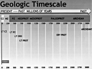
Figure 11.1 Schematic of the five main ice age
periods in uniformitarian earth history. The Archean “ice age” is
still speculative. The ice age labeled LT CZ (late Cenozoic)
represents the post-Flood Ice Age that uniformitarian geologists
call the Pleistocene or Quaternary. The other four labeled “ice
ages” or “ancient ice ages” are considered to be caused by giant
landslides during the Genesis flood and not real ice ages. |
Why multiple ice ages?
In the mid 1800s, when scientists began to realize that ice
sheets had overrun large tracts of land in the mid and high latitudes, they at
first thought there had been only one ice age. As they began to look at glacial
debris in more detail they concluded that ice ages may be more complicated than
they had originally thought. At the periphery of the ice sheets they found
glacial debris layers separated by sand and gravel. This, they thought, was
proof of multiple glaciations.
The idea of multiple glaciations caught on. It quickly became
the new ice age paradigm — a supermodel in which to fit subsequent research
data. After all, according to the uniformitarian principle, if there was one ice
age, why not many? Multiple ice ages, to many scientists, was a more satisfying
idea because the idea conformed to their assumption of uniformitarianism and
helped fill its need for time. A number of scientists, however, still thought
the evidence was equivocal and that one ice age could cause multiple till
layers. They attributed the layers to an ice sheet edge advancing and
retreating. But their view eventually lost favor.
That generation of scientists died and a new one took its place,
one that was conditioned to think in terms of multiple glaciations. The new
breed of geologists went on to consider how many ice ages there were. Scientists
settled on about four ice ages in the early 1900s, due to the work of Albrecht
Penck and Eduard Bruckner, who convinced the world that four river terraces
north of the Alps showed meltwater deposits from four different ice caps. So,
the four-ice-age hypothesis was born and caught hold. Scientists who believed in
an early version of the astronomical theory of the ice age saw more than four
ice ages in the river terraces, since their theory demands many more than four.
However, the astronomical theory was considered too feeble to cause ice ages, so
the belief in four ice ages prevailed and was accepted doctrine for about
60 years.
From the Alps research, glacial
geologists working in other areas also saw only four ice ages.2
It became conventional wisdom to postulate four ice ages, based on deposits at
the edge of the ice sheets in the north central United States and in northern
Eurasia. Table 11.1 shows the glacial and interglacial classification from the
Midwest that was in vogue for about 60 years. There is an interesting
progression that occasionally occurs in science, especially historical sciences,
that wrong concepts get “proved” over and over again. This is called the
bandwagon effect or reinforcement syndrome. During the time when the
four-ice-age theory dominated thinking, all relevant data was fitted into this
theory. There appeared to be no contradictions.
| Glacial |
Interglacial |
| Wisconsinan |
Holocene or recent |
| Illinoian |
Sangamon |
| Kansan |
Yarmouth |
| Nebraskan |
Aftonian |
|
Table 11.1. The classical glacial-interglacial
sequence of the north-central United States |
It was all fiction, developed on preconceived ideas of how
glaciers are expected to behave. In the 1970s, ideas changed and now scientists
are postulating 30 regularly repeating ice ages! Nevertheless, as with all
ruling theories, all of the data has been, once again, massaged into the new
ruling theory. Few scientists dare risk their careers and grant money to point
out the theory’s glaring contradictions.
History indicates that the number of glaciations has never been
on a solid footing. It has changed according to the popular ideas of the time.
One recent Ice Age?
It may come as a surprise to many
people, but there is strong evidence there was only one fairly recent ice age.3
In
an earlier
chapter, I showed just how meteorologically difficult it is for any ice age
to develop using present processes. For snow to survive a summer in the northern
United States, summer temperatures would have to drop to an average of about
20°F (–7°C), 50°F (28°C) below normal, and the snow needs to be regularly
replenished. According to uniformitarianism, this abnormal climate has to
persist for thousands of years. If one ice age is difficult to produce, how much
more difficult would it be to form 2, 4, 15, or 30 ice ages in succession?
When we examine the glacial debris
called till, we learn that it was deposited predominantly from the last Ice
Age even within the uniformitarian paradigm. Moreover, most of this till is
from the last advance of the last ice age.4
Sugden and John5 state in reference to
ice ages other than the last:
We shall not, therefore, consider these [previous]
glaciations in any detail — a task which would in any case be difficult
because of the scarcity of supporting evidence.
The glacial deposits themselves point to only one ice age.
When you compare the till to the
bedrock below, you usually discover that the debris is the same as the bedrock
material and, therefore, was not transported very far. Feininger6
writes:
Earlier in this report, the nearness of most glacial
boulders to their source was cited as evidence that glacial transport is
generally short. Even stronger evidence to support this view can be read
from the tills themselves. Where the direction of movement carried a
continental ice sheet from one terrain to another of markedly different rock
type, the tills derived from each terrain are predominantly restricted to
the area of their corresponding source rock.
A short distance of transport would be expected in one ice age,
but in multiple ice ages, the debris should be bulldozed farther and farther
from its source. Since most glacial till is from local bedrock, one ice age is a
more straightforward deduction.
 |
 |
|
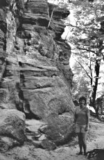
Figure 11.2. (Above) Sandstone spires in
southwest Wisconsin indicating the area has never been glaciated,
otherwise the ice sheets would have planed the area.
Figure 11.3. (Left) Close-up of a sandstone spire
shown in figure 11.2. |
A few areas within the periphery of the ice sheet in North
America were never glaciated at all. These are called driftless areas and have
been mentioned in a previous chapter. Sandstone spires (that were not planed
off) are evidence that the driftless area in southwest Wisconsin was never
glaciated (figures 11.2 and 11.3). How can a thick ice sheet over a 100,000-year
period in the uniformitarian paradigm have missed these areas? Even more
puzzling is how 30 or more ice ages could have missed these driftless areas. A
thin ice sheet that formed and melted rapidly has a much greater chance of
leaving a few areas unglaciated at the margin than many long ones.
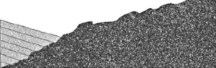
Figure 11.4. Schematic showing that the same
topographic roughness of the granite in southeast Canada continues
under the sedimentary rocks to the south. |
With the many presumed glaciations of
Canada, Canada’s bedrock should be heavily eroded. However, the terrain, in
truth, shows little erosion.7 The bedrock
under the local cover of sedimentary rocks is of the same topographical
roughness as that found on the exposed crystalline bedrock (figure 11.4).
The characteristics of ice age animals
points to a single ice age. During the approximately two to three million years
that uniformitarian scientists allot to multiple glaciations, the animals
remained much the same.8 There is very
little fossil information available to differentiate between various glacials
and interglacials. Their explanation is that very little evolution took place
because the many ice ages apparently did not stress the animals to change. Then
for some mysterious reason, dozens of large mammals and birds went extinct after
the “last” ice age. This appears doubtful within their evolutionary paradigm.
One ice age with characteristic plants and animals is a more reasonable
deduction.
If there were multiple interglacials, animals such as reindeer
and woolly mammoths would successfully recolonize previously glaciated
territory. Their bones should be abundant in these areas, but they are rare and
are found mainly at the periphery of ice sheets and in non-glaciated areas.
Table 11.2. Summary of evidence supporting only one ice age
-
One ice age meteorologically difficult
-
Most till local
-
Most till predominately from the “last”
-
Most North American loess from the “last”
-
Interior till thin and coarse-grained
-
Bedrock slightly eroded in interior areas
-
Inadequate thickness of periphery till
-
Driftless areas within periphery
-
Little change in flora and fauna
-
Fossils rare in glaciated regions
-
Most extinctions after the “last”
|
Lastly, if the uniformitarian version of multiple ice ages were
true, at least 1 of the 30 ice ages should have glaciated the lowlands of
Siberia, Alaska, and the Yukon. Could it be there really were no interglacials?
The broad-scale evidence for only one
ice age is summarized in table 11.2. When it comes right down to it, the
uniformitarian scientists actually assume there were multiple ice ages.
Young and others9 admit:
Glacial reconstructions commonly assume a multiple-glaciation
hypothesis in all areas that contain a till cover.
It all adds up to a strong case for one recent Ice Age.
How can one Ice Age explain the evidence for multiple ice ages?
Although scientists have been operating under preconceived
concepts for interpreting glacial data, they do have some physical evidence that
supports the multiple glaciation hypothesis. This mainly consists of presumed
interglacial deposits between layers of till and the old appearance of some
glacial debris, especially in the north-central United States.
The foremost evidence for multiple
glaciation comes from the periphery, where till layers are sometimes separated
by layers of sand, gravel, clay, or even organic material. However, the sand and
gravel are glacial melt debris. It is easy to sandwich this debris between
layers of till, even within the interior of a single ice sheet.10
The edge of an ice sheet or glacier is now known to oscillate many times over
short periods. Glaciers advance, retreat, readvance, and even surge. A surge is
a sudden increase in glacial flow that goes from normal to perhaps one hundred
times faster over a period of a few months and sometimes for as long as three
years. During a surge, a glacier has often moved many miles. Scientists now
recognize that surges were common at the edge of the ice sheets. Even scientists
who are committed to the present processes paradigm are coming to the conclusion
that one ice sheet can cause multiple till layers with nonglacial deposits or
melt debris between them. Derbyshire11
writes:
Long-standing problems of interpretation of complexly
interbedded tills of the Pleistocene glaciations have been resolved as a
result of the realization that not all tills are of subglacial origin, and
that a formation of several tills interbedded with meltwater stream deposits
may be the product of a single advance and retreat of the glacier.
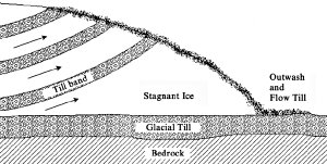
Figure 11.5. Shearing of basal ice and debris at
the snout of a glacier. Retreats and advances of the glacier cause a
complex mixture of till, flowtill, and outwash deposits after the
ice melts that have been mistaken for multiple glaciation. |
Derbyshire12
even shows how shearing layers of debris-rich till over a stationary lower layer
of ice would result in stacked debris bands that look, upon melting, like
multiple till sheets (figure 11.5). Most of this shearing takes place at the ice
sheet margin and can be repeated many times. Other authors confirm Derbyshire’s
conclusion.
It is interesting that the first claim
for multiple ice ages was later shown to be a likely minor oscillation at the
edge of one glacier.13 Based on
new concepts of glacial dynamics, geologists have concluded that only one ice
age affected much of Alberta, Canada.14
Beaney and Shaw15 recently summarized
the evidence for western Alberta:
The suite of landforms was interpreted as evidence for
multiple advance and retreat cycles of the Laurentide ice sheet. These
interpretations are brought under question with the conclusion that there
was only a single glaciation, the Late Wisconsinan, of the western part of
the Alberta Plains … .
Organic remains, commonly associated
with interglacials within the multiple glaciation paradigm, are rare in
glaciated areas, as Charlesworth16
states:
… glacial deposits are virtually unfossiliferous;
interglacial accumulations, if fossiliferous, occur in isolated and
discontinuous patches … .
Eyles17
finds that organic material associated with till can be incorporated by glacial
readvances. So, a dynamic ice sheet that oscillates at its margin would be
expected to pick up organic remains, especially plant material, now and then. If
an ice sheet advances far enough, it could cover forests and animal bones that
would be located just south of the sheet, especially if the Ice Age had mild,
wet winters and the animals and plants lived close to the edge.
In the Midwest, sticky clay layers,
called gumbo, are found either between till sheets or on top of glacial
debris. This has been interpreted as a soil that took much time to develop
during an interglacial period. However, many of these “soils” are controversial.
Some soil scientists believe this clay can form in areas of poor drainage, which
means that the clay can form quickly in a wet climate. It is even possible that
some of the clay layers could form at the bottom of a lake adjacent to the ice
sheet. Soils usually have an organic layer at the top, but the Midwest clay
layers nearly always are missing the top organic layer.18
In conclusion, the idea that these clay layers represent interglacial times
between ice ages is a stretch.
The old, weathered appearance of some glacial deposits could be
explained by several processes within a post-Flood ice age. One possibility is
that much heavier precipitation in an equable climate could cause faster
weathering. Another, more likely, possibility is acid rain. One of the primary
volcanic gases during the Ice Age was SO2. When combined with water,
SO2 will form sulfuric acid. The resulting acid rain would tend to
cause very rapid weathering and an old appearance in a short time.
In summary, one dynamic ice age during the unique post-Flood
climate can account for many, if not all, of the features of the glacial
deposits that appear to support multiple glaciations. Other interpretations,
like clay soils, may simply be a misinterpretation.
Is the next ice age due soon?
A global superstorm is coming soon,
say Art Bell and Whitley Strieber19 in
their provocative book The Coming Global Superstorm. They give dire
warnings of a storm so devastating that it will quickly usher in another ice
age.
The entire American Midwest would be under a sheet of ice,
one that would extend across Siberia and northern Europe as well. …
The ice keeps coming back, and we
aren’t sure why. But something acts as the trigger, and we know that this
event is a sudden one. … the victims — some of them frozen so quickly that
their dinners are still in the mouths — will not be found again for
thousands of years. Like the mammoths who preceded them in the last storm,
their remains will suggest to the future that something strange and terrible
happened. … For the past 3 million years, earth has been in an agonizing
cycle of alternating Ice Ages and brief warming periods.20
Notice that the quick-freeze of the woolly mammoths in Siberia
is used as an analogy of what will happen to man in a future ice age. Daniel
Grossman in the July 22, 2003, New York Times warns us:
If the past is any indication, the earth is at the end of
another such warm period, poised to descend into a new Ice Age.
Their evidence for such a frightening scenario consists of the
popular idea that ice ages have repeatedly occurred over 90 percent of the past
2.5 million years and that each intervening warm spell lasted only 10,000 years.
According to uniformitarianism, the last ice age ended about 10,000 years ago,
so the next one is about due. To further support their theory, they contend that
solar radiation absorbed in the higher latitudes has fallen to the level of the
peak of the last ice age. This is thought to be due to the earth’s orbital
geometry in accordance to the currently popular astronomical theory of the ice
ages.
Large fluctuations in oxygen isotope
ratios in Greenland ice cores are also thought to signal rapid climatic changes.
Oxygen comes in three isotopes with different numbers of neutrons in the atoms.
When there is more oxygen-16 than oxygen-18 in the ice, the climate is assumed
to have been colder. For the past 30 years, glacial geologists have drilled ice
cores on the Greenland ice sheet. In the early 1990s, they were surprised to
discover rapid changes in oxygen isotope ratios, which suggested to them that
there were rapid changes in climate, possibly up to 36°F (20°C) within a few
decades!21 There is much evidence that
ice cores from the Greenland and Antarctic ice sheets support the creation-Flood
Ice Age model and not the uniformitarian model.22
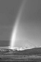
Figure 11.6 |
This is an example of how
uniformitarian beliefs can get us into a lot of trouble. As we already know, ice
ages are not easy to develop. Although the summer radiation at higher latitudes
is similar to what it was at the peak of the Ice Age, the world is nowhere close
to producing another ice age. Secondly, there was only one trigger known to be
strong enough to produce an ice age — the Genesis flood. God has promised not to
send another Flood on the earth. The rainbow’s association with rain and
thunderstorms is a frequent reminder of His promise from
Genesis 9:11–17 (figure 11.6). If there will never be another global Flood,
then there obviously will never be another ice age.
Were there ancient ice ages?
Geologists believe ice ages existed
not only in the recent past but also in the ancient past. Figure 11.1 shows the
times of supposed ice ages within geological time. Ancient ice ages go back 2 to
2.5 billion years ago in the standard geological time scale. Creationists, on
the other hand, would consider that most of the sedimentary layers on the earth
were laid down by the Flood. Because of the acceptance of multiple ice ages,
those opposed to creation question how ice ages can occur with only one flood.
Anti-creationist Arthur Strahler23
points out what he thinks is a major contradiction to the biblical time scale in
this way:
The Carboniferous tillites cannot be accepted by
creationists as being of glacial origin for the obvious reason that the
tillite formations are both overlain and underlain by fossiliferous strata,
which are deposits of the Flood. During that great inundation, which lasted
the better part of one year, there could have been no land ice formed by
accumulation of snow.
Tillite is the consolidated equivalent of glacial till. I
believe Strahler is correct in that there could have been no land ice or
glaciation during the Flood. Then how do we explain the rocks that are used as
evidence for ancient ice ages?
 |
 |
|
Figure 11.7. (Top) Hardened glacial till. Note
the stones of various sizes embedded in a finer-grained matrix.
Figure 11.8. (Above) Striated bedrock below
“tillite” from the supposed late Paleozoic glaciation in southern
Africa. (Photo by Gordon Davison) |
The rocks representing these assumed ice ages look like hardened
glacial till (figure 11.7). Furthermore, they exhibit other features that are
thought by many to only be caused by ice. They show striated rock surfaces,
striated rocks within the till, and stones in finely layered sediments. Figure
11.8 shows a picture of striated and polished bedrock below “tillite” from the
most famous ancient glaciation, the late Paleozoic or Carboniferous/Permian “ice
age” from southern Africa. The stones in finely layered sediments are suggestive
of lakes adjacent to a glacier in which debris-rich icebergs break off and float
out over the lake. As the iceberg melts, stones in the ice are dropped into the
fine mud on the lake bottom.
Supposed ancient ice ages are not
unlike other challenges from geologists to the Genesis flood and the creation’s
short time scale. Further analysis of the data is called for, and it provides a
different explanation for these rocks.24
The rocks in question have a number of peculiar properties suggesting that they
likely are not ice age related. First, the vast majority of these “tillites” are
marine deposits. Second, they hardly show the dimensions of glacial
debris, being geographically small and commonly thick, unlike glacial deposits
that are the opposite. Third, the stones in the “tillite” are generally small
and random, while glacial deposits from the recent Ice Age commonly contain
masses of boulders. Fourth, there are a number of geological features for the
presence of ice that should exist in these “tillites” but are absent. Fifth,
paleomagnetism indicates that most of the numerous “ice age” deposits older than
500 million years in their geological time scale occurred near the equator.
This data has spawned the serious consideration that the earth was totally
glaciated for several long stretches of time from about 3 billion years to 500
million years ago.25 Lastly, the
so-called glacial debris is intimately associated with warmth indicators such as
carbonates and dolomites.
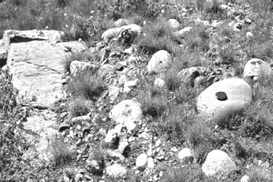
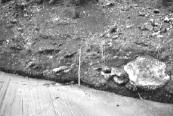
Figure 11.9. Landslide debris that scratched the
bedrock. Some of the stones in the debris are scratched. |
So, we observe a number of
glacial-like features in the “tillite” rocks and a number of features hostile to
ice ages. Are there other geological processes that can account for the data
used to postulate ancient ice ages? Yes, there are other processes that can
account for the data we observe, namely underwater landslides of various sorts.
Landslides can striate bedrock as they slide over it and at the same time
scratch up the stones in the landslide material. Figure 11.9 is a photo of a
landslide that scratched the bedrock below and the stones in the debris.
Schermerhorn26 takes other geologists
to task for not considering other mechanisms for striated stones:
To repeat the most important point, great caution is urged
in the use of striated stones as glacial pointers. It is a point that has
been stressed time and again by many stratigraphers, without apparently
leaving much impression.
It seems that geologists have developed too strong a bias toward
ancient ice ages to seriously consider other mechanisms for the observed rocks.
The very dynamic Genesis flood produced rapid sedimentation and
landslides of unstable sediments. These landslides could duplicate the large
scale of some of these “tillites.” Landslides would be caused by tectonic motion
and huge earthquakes that occurred during the Flood. It is known that the larger
the landslides, the farther they travel. Hence, monstrous Flood landslides are
bound to cause some unconsolidated sediments to slide long distances and come to
rest on nearly level strata, as is observed in these supposed ancient ice age
deposits.
Landslides in the Genesis flood can also result in striated
bedrock, striated rocks in the debris, and other supposed glacial features. The
Flood is probably the only possible mechanism that can explain one unique
feature of a “tillite” in the Sahara Desert. A grooved substratum has been
observed in the Sahara Desert that covers many hundreds of square miles.
However, in the Sahara Desert these grooves mostly all point north! Ice
sheets have never been observed to produce such consistent directional
indicators over such a wide area. Large underwater landslides during the Flood
would be expected to continue moving in the same direction once the motion was
initiated, and thus groove and striate the bedrock in the same direction over
many hundreds of square miles.
So these so-called ancient ice ages
can be explained as gigantic underwater landslides during the Genesis flood.27
http://www.answersingenesis.org/home/area/fit/chapter11.asp