 Sand
Transported Cross Country: Flood Evidence
Number Four by Andrew A. Snelling
Sand
Transported Cross Country: Flood Evidence
Number Four by Andrew A. SnellingWe find layers of thick sandstone around the earth. Where did the sand come from? Evidence indicates it was carried across entire continents by water circling the globe.
Genesis 7 says that all the high hills and the mountains were covered by water, and all air-breathing life on the land was swept away and perished. After reading this passage, wouldn’t we expect to find rock layers all over the earth filled with billions of dead animals and plants that were rapidly buried and fossilized in sand, mud, and lime? Yes, and that’s exactly what we find.
Sediment Transported Long Distances
In previous articles we have already seen the evidence that rapidly deposited sediment layers containing rapidly buried plant and animal fossils are found spread across vast areas, often high above sea level. No known slow-and-gradual geologic processes in the present world are currently producing such fossiliferous sediment layers spread across continents. Though evolutionary geologists are loath to admit it, only a global flood in which the ocean waters flooded over the continents could have done this.
Six main geologic evidences for the Genesis Flood
Introduction: Geologic Evidences for the Genesis Flood
Evidence #1. Fossils of sea creatures high above sea level
Evidence #2. Rapid burial of plants and animals
Evidence #3. Rapidly deposited sediment layers spread across vast areas
Evidence #4. Sediment transported long distances
Now it logically follows that, when the Flood waters swept over the continents and rapidly deposited sediment layers across vast areas, these sediments had to have been transported long distances. In other words, the sediments in the strata had to come from distant sources. And that’s exactly the evidence we find.
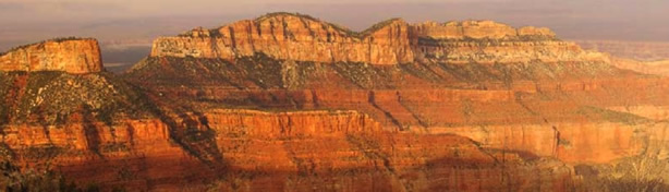
For example, in the previous issue we discussed the Coconino Sandstone, seen spectacularly in the walls of the Grand Canyon (Figure 1). It has an average thickness of 315 feet (96 m), covers an area of at least 200,000 square miles (518,000 km2), and thus contains at least 10,000 cubic miles (41,700 km3) of sand.1 Where did this sand come from, and how do we know?
The sand grains are pure quartz (a natural glass mineral), which is why the Coconino Sandstone is such a distinctive buff color. Directly underneath it is the strikingly different red-brown Hermit Formation, consisting of siltstone and shale. Sand for the Coconino Sandstone could not have come from the underlying Hermit Formation.

The sloping remnants of sand “waves” in the Coconino Sandstone point to the south, indicating the water that deposited the sand flowed from the north.2 Another clue is that the Coconino Sandstone thins to zero to the north in Utah, but the Hermit Formation spreads farther into Utah and beyond. So the Coconino’s pure quartz sand had to come from a source even farther north, above and beyond the red-brown Hermit.
Grand Canyon has another set of layers with sand that must have come from far away—the sandstone beds within the Supai Group strata between the Hermit Formation and the Redwall Limestone. In this case, the sand “wave” remnants point to the southeast, so the sand grains had to have been deposited by water flowing from a source in the north and west. However, to the north and west of Grand Canyon we find only Redwall Limestone underneath the Supai Group, so there is no nearby source of quartz sand for these sandstone beds.3 Thus an incredibly long distance must be postulated for the source of Supai Group sand grains.4
Other Sediment Even Transported Across the Continent
A third layer of sandstone higher in the strata sequence gives us a clue. The Navajo Sandstone of southern Utah, best seen in the spectacular mesas and cliffs in and around Zion National Park (Figure 2), is well above the Kaibab Limestone, which forms the rim rock of the Grand Canyon. Like the Grand Canyon sandstones, this sandstone also consists of very pure quartz sand, giving it a distinctly brilliant white color, and it also contains remnants of sand “waves.”
Within this sandstone, we find grains of the mineral zircon, which is relatively easy to trace to its source because zircon usually contains radioactive uranium. By “dating” these zircon grains, using the uranium-lead (U-Pb) radioactive method, it has been postulated that the sand grains in the Navajo Sandstone came from the Appalachians of Pennsylvania and New York, and from former mountains further north in Canada. If this is true, the sand grains were transported at least 1,800 miles (3000 km) right across North America.5
This “discovery” poses somewhat of a dilemma for conventional uniformitarian (slow-and-gradual) geologists, because no known sediment transport system is capable of carrying sand across the entire North American continent during the required millions of years. It must have been water over an area even bigger than the continent. All they can do is postulate that some unknown transcontinental river system must have done the job. But even in their scientific belief system of earth history, it is impossible for such a river to have persisted for millions of years.
Yet the evidence is overwhelming that the water was flowing in one direction. More than half a million measurements have been collected from 15,615 North American localities, recording water current direction indicators throughout the geologic record. The evidence indicates that water moved sediments across the entire continent, from the east and northeast to the west and southwest throughout the so-called Paleozoic.6 This general pattern continued on up into the Mesozoic, when the Navajo Sandstone was deposited. How could water be flowing across the North American continent consistently for hundreds of millions of years? Absolutely impossible!
The only logical and viable explanation is the global cataclysmic Genesis Flood. Only the water currents of a global ocean, lasting a few months, could have transported such huge volumes of sediments right across the North American continent to deposit the thick strata sequences which blanket the continent.7
The geologic record has many examples of sediments that did not come from erosion of local, underlying rocks. Rather, the sediments had to have been transported long distances, in some cases even across continents. This is confirmed by water current direction indicators in these sedimentary layers, which show a consistent uni-directional flow. However, conjectured transcontinental river systems could not have operated like that for hundreds of millions of years. Instead, only catastrophic global flooding of the continents over a few months can explain the huge volumes of sediments transported across the continents.
In Genesis 7–8 the Bible describes the cataclysmic global Flood in which the waters covered the whole earth, sweeping across entire continents. We would expect to find that these global waters eroded sediments and transported them across whole continents to be deposited in layers covering vast areas. We have now seen that this is exactly what we find across North America, so there is no excuse for claiming there is no evidence of a global flood. The global cataclysmic Genesis Flood actually happened in the earth’s history, just as God told us it did.

Footnotes
- D. L. Baars, “Permian System of Colorado Plateau,” American Association of Petroleum Geologists Bulletin 46 (1962):200–201; J. M. Hills and F. E. Kottlowski, Correlation of Stratigraphic Units of North America-Southwest/Southwest Mid-Continent Region (Tulsa, Oklahoma: American Association of Petroleum Geologists, 1983); R. C. Blakey and R. Knepp, “Pennsylvanian and Permian Geology of Arizona,” in J. P. Jenney and S. J. Reynolds, eds., “Geologic Evolution of Arizona,” Arizona Geological Society Digest 17 (1989):313–347.
- S. A. Austin, ed. Grand Canyon: Monument to Catastrophe, (El Cajon, California: Institute for Creation Research, 1994), p. 36.
- J. S. Shelton, Geology Illustrated (San Francisco: W. H. Freeman, 1966), p. 280.
- R. C. Blakey, “Stratigraphy of the Supai Group (Pennsylvanian-Permian), Mogollon Rim, Arizona,” in S. S. Beus and R. R. Rawson, eds., Carboniferous Stratigraphy in the Grand Canyon Country, Northern Arizona and Southern Nevada (Falls Church, Virginia: American Geological Institute, 1979), p. 102.
- J. M. Rahl, P. W. Reiners, I. H. Campbell, S. Nicolescu, and C. M. Allen, “Combined Single-Grain (U-Th)/He and U/Pb Dating of Detrital Zircons from the Navajo Sandstone, Utah,” Geology 31.9 (2003):761–764; S. R. Dickinson and G. E. Gehrels, “U-Pb Ages of Detrital Zircons from Permian and Jurassic Eolian Sandstones of the Colorado Plateau, USA: Paleogeographic Implications,” Sedimentary Geology 163 (2003):29–66.
- A. V. Chadwick, “Megatrends in North American Paleo-currents,” http://origins.swau.edu/papers/global/paleocurrents/default.html, 2007.
- L. L. Sloss, “Sequences in the Cratonic Interior of North America,” Geological Society of America Bulletin 74 (1963):93–114.